


Total Results:
Introduction To Digital Navigation
Discover the Future of Marine Navigation with our "Introduction to Digital Navigation" course - From £149
Digital Navigation has been part of our lives for quite some time. From the Sat Nav in our vehicles to the Smartwatches tethered to our mobile phones, we all use Apps and websites to check our location, orientation and probably the weather.
By gaining those essential digital navigation skills, you can 'Set Sail' with confidence. Our Introduction to Digital Navigation course is designed for all boating enthusiasts and who wish to learn how to harness the power of modern technology, ensuring safer, smarter and stress free planning.
£124.17
Introduction to Digital Navigation - Solent Boat Training
Solent Boat Training offer an 'Introduction to Digital Navigation' training day and is suited to those who have already completed their boat training to become the skipper of a vessel, wishing to improve on their currently knowledge and understanding of navigation equipment or just want a brush up, before heading back onto the water.
During this hands-on course, your instructor will introduce you to a number of eNavigation tools currently available (some you may already be using). This will ensure a better understanding of which ones might be right for you and how to utilise them as part of your planning.
The morning will start with an explanation of how the information gathered, can best be interpreted. It is important to understand any information gained from Apps, Websites, GPS's and Digital Charts, to give a better appreciation of the data offered and how it will assist in your day to day navigation.
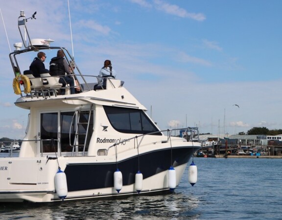
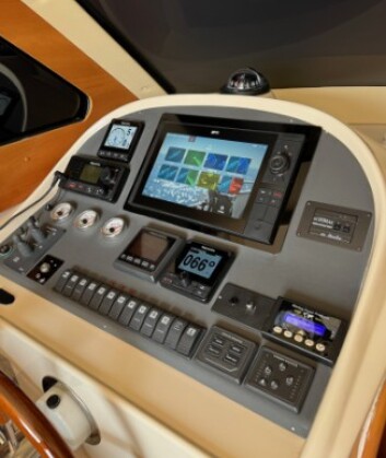
Having identified the various sources of information, you will then have the opportunity to put this into practice during the afternoon sessions, where you'll be encouraged to create and run a route using the latest Raymarine Navigation Equipment , fitted to our Rodman 1040 Adv Motor Cruiser see more details 'Here'
You will be given the chance to formulate a route as you navigate down the Itchen River and then into Southampton Water. Individually or as a group, you will be able to follow your digital plan and navigate in confidence, safe in the knowledge that your instructor is on hand to offer advise and clarification.
With a greater emphasis towards eNavigation and the use of Digital Charts, it is vital that the operator of any vessel must be fully conversant with the equipment available to them. While Electronic Chart Display and Information Systems (ECDIS) are not new, there are many variations of each.
Having a basic understanding of what information a system can provide you with and how best to utilise the data, will increase the effectiveness of a device and give you a better understanding of any limitations it may pose.
As accurate as the data offered by the many pieces of online, mobile apps or live data available to the user might be, the ability to fully understand and interpret this, is a skill that can only be gained with practice.
Being presented with so much data and information is great, but location awareness is still the most vital part of navigating afloat. Disorientation is one of the key factors, we as vessel operators must avoid at all costs. Being lost is not just unsafe to our vessel, but can also effect others.
For example;
1. Where did your weather forecast originate from, is it accurate or is it only a prediction?
2. Is the Tidal app you're using give you adjusted timings for DST or best guess for the area you are operating in?
3. Is the position offered by your GPS or Chart Plotter using the correct Datum, True or Magnetic Bearings or does it even running the most up to date software and chart data?
4. Before using the Auto Route function of your Chart Plotter, did you input the correct data to ensure your passage will be a safe one?
Enhance your Digital Navigation Skills with some of the leading Marine Apps and Navigation Systems
As part of our our Introduction to Digital Navigation course, we'll introduce you to some of the most common apps used in modern day boating. These allow you to identify weather and tidal conditions, enabling you to combine this with your current onboard navigation equipment. These include:
RYA the Rise of eNavigation - 'Click Here'
- Windy: Get real-time wind, wave, and weather forecasts, helping you plan your route safely and effectively, no matter the conditions.
- XC Weather: Access detailed wind and weather data, tailored for sailors and boaters, to ensure you're always prepared for what’s ahead.
- Met Office: Stay updated with the latest official UK weather forecasts, warnings, and live weather conditions, all in the palm of your hand.
- Windfinder: Get detailed wind forecasts, perfect for planning your day on the water, with a focus on tide and wind conditions.
- Boatie: Keep track of your position, route, and voyage log easily with this app, designed specifically for boaters looking for a simple and effective navigation tool.
- Imray Tides Planner: Access accurate tidal data, helping you plan your journey around tidal patterns, ensuring you're always in the right place at the right time.
- Navionics: One of the most trusted navigation apps, providing detailed charts and mapping. allowing you to plan routes with confidence and accuracy.
- Savvy Navvy: A versatile app offering seamless GPS tracking and plotting, with ability to overlay detailed charts and access key navigational data.
- Imray Navigator: A powerful app with access to Imray's extensive range of marine charts, designed to guide you through safe waters with ease.
If you are already using anyone of these Apps or wish to download them to a device prior to the course, bring your device along and you'll get the opportunity to use them on the day.
office@solentboattraining.co.uk
Shamrock Quay
William Street
Southampton
Hampshire
SO14 5QL
UNITED KINGDOM
